The Vermilion cliffs
Located in a remote region of Northern Arizona near the Utah border, The Vermilion Cliffs National Monument is a must-see destination for landscape and outdoor recreation photographers- see more photos below. This nearly 300,000 acre preserved area offers stunning views of the vibrant colored and rugged Vermilion Cliffs that rise abruptly to over 7,000 feet elevation in some spots. In addition, this area contains a variety of diverse landscapes and features including broad valleys, plateaus, deep slot canyons, unique geological formations, as well as the mighty Colorado river located nearby in the adjacent Lee’s Ferry and Glen Canyon recreation area. Other popular attractions and destinations nearby include the North Rim of the Grand Canyon, The White Pocket geological formation, and the famous Wave.
Condors:
The Vermilion Cliffs are also home to the rare and endangered California Condor. There are only approximately 300 of these magnificent birds living in the wild today and approximately 70 to 80 live in the Vermilion Cliffs and Glen Canyon Recreation area as well as the South Rim of the Grand Canyon. As the largest bird in North America with wing spans up to 10 feet, they are hard to miss if they are soaring nearby. I would recommend visiting and walking out on the Historic Navajo bridge near the entrance of Marble Canyon off Highway 89A as giving you your best opportunity of seeing a Condor in this area. The epic view from the Bridge of the surrounding Vermilion Cliffs and the blue/green waters of Colorado river nearly 500 feet below is worth the effort by itself.
Highway 89A is the main portal to this sparsely populated and high desert landscape and in my opinion is one of the most beautiful drives in the Four corners region. In addition to the Navajo Bridge interpretive center, there are many other points of interest and wide pull-outs that are ideal to stop, snap some photos, and soak up the scenery and scale of this classic American Southwest landscape.
Below are a few images and a video link with some additional info and some very basic photography tips about the Vermilion Cliffs area in Arizona. Please click on the images to see full size high resolution versions that are available for sale. Please contact me if you have any questions or see an image you like that is not linked. This is just a small sampling of the images I have for this unique and uncrowded American Southwest location.
Some Other Services I Offer
Photo Restoration: View info here about my old photo restoration services
Photo Editing: See details here about my freelance photo editing services
Video Editing: View info here about my affordable freelance video editing services
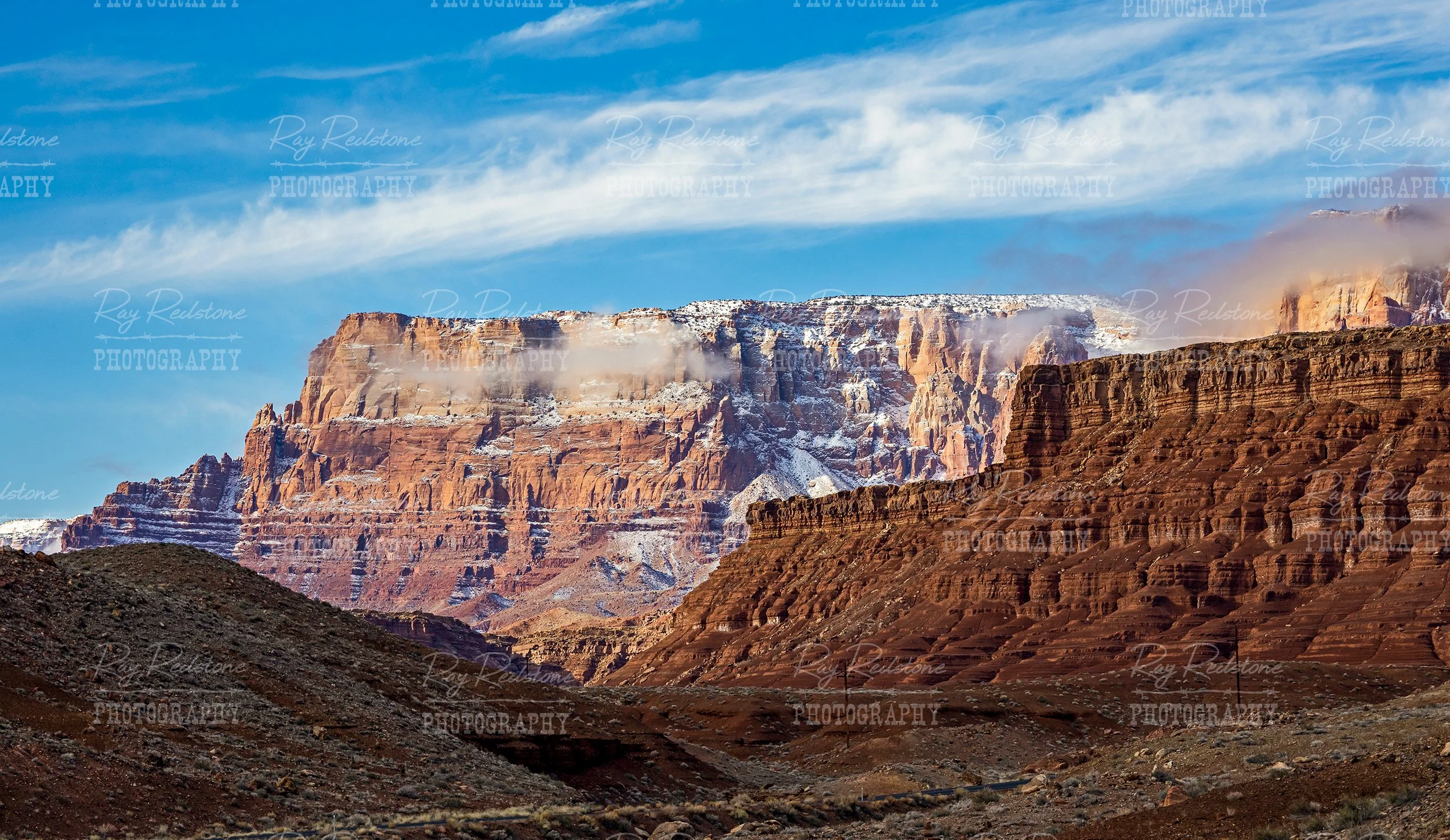
Snow blasted Vermilion Cliffs along Highway 89A in Marble Canyon, AZ.

Highway 89A leads you directly into the heart of the expansive Vermilion Cliffs Monument region .
Some cool winter and snowy scenes from the Vermilion Cliffs Monument area.
Remote Highway 89a with a view of the snow dusted Vermilion Cliffs after a winter storm in 2023. With elevations near 7,000 feet, its not to uncommon for snow storms in this high desert environment.

This is a view of the rugged Vermilion Cliffs from the Cathedral rock trailhead on the road to the Lee’s Ferry recreation area.
This is an expansive and panoramic view of the Vermilion Cliffs off the beautiful and remote highway 89A that runs through Marble Canyon.
This is a close up view of the snow dusted Cliffs captured at the Lee’s Ferry campground.

The Navajo Bridge interpretive center with the snow clad Vermilion peaks in the background.

There are plenty of pull offs on highway 89A to capture some dramatic images of the Cliffs and local residents like this painted pony. This is high desert so it does occasionally snow in the winter season especially in the higher reaches of the cliffs which soar up to 7,000 feet elevation.

A lone free range horse visits a water hole on the Navajo reservation with the Vermilion cliffs in the background.

This is an elevated view of the Vermilion Cliffs and the snow blasted Kaibab Plateau in the background. The Kaibab plateau dead ends at the remote North Rim of the Grand Canyon.
Another elevated view of the Vermilion Cliffs a t sunrise time. A good location to capture broad and elevated images of the Cliffs is from a designated pullout with lots of parking space on the left hand side of Highway 89 heading up the hill to Page Arizona.
This is a close up view of some of the higher reaches of the Vermilion Cliffs that I was fortunate enough to visit one morning after a long and bumpy ride on an ATV. This image gives you a good idea of how dramatic and rugged this epic landscape is.
Explorers travelling on a narrow and rough road into the upper reaches of the Vermilion Cliffs.

A Lone fly Fisher on the Colorado River with the Vermilion Cliffs looming in the background. You can view more Lee’s Ferry Fly Fishing images here.

The rising sun lights up the Vermilion Cliffs at the Lee’s Ferry campground.
View a short video with stunning scenes from the Vermilion Cliffs area in Northern Arizona.
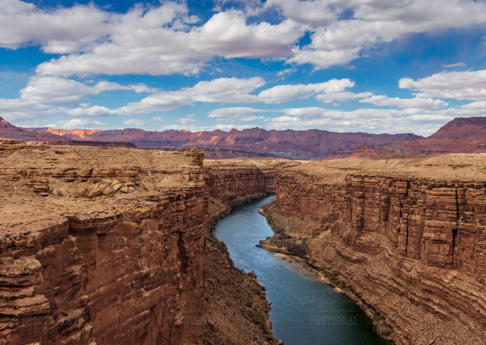
This is your view of the Colorado river from Navajo Bridge.

As mentioned in the initial narrative, rare California Condors are present in the Vermilion Cliffs Monument area. These 2 birds were hanging out just below Navajo Bridge.

This is a popular overlook on the road to Page that provides a sweeping view of the Vermilion Cliffs and the Kaibab plateau in the distance. The high elevation Kaibab plateau leads to the North Rim of the Grand Canyon. Its an epic and beautiful drive from Marble Canyon to the North Rim. But make sure you check the conditions in the winter months as highway 67 leading to entrance of the North Rim part of the park could be closed because of heavy snow.