my adventure going over a snowy cinnamon pass near Silverton co

Back in mid-September in 2017, I had the incredible (and a little nerve wracking) experience of traversing the rugged Cinnamon Pass, one of the iconic routes in the Alpine Loop near Silverton and Lake City, Colorado. Nestled in deep the remote San Juan Mountains of Southwest Colorado, this off road adventure is probably not for everyone, but it the conditions are right, this area can offer some memorable off-roading and truly outstanding Rocky Mountain views.
Leaving Telluride:
I left my campsite in the Telluride area about 7:30 am to begin my back country off roading adventure on the Alpine loop with the weather looking good. But, as someone who has been exploring and camping in this part of Southwest Colorado over 20 years, I knew firsthand that conditions can change rapidly in the San Juan Mountains. In this high elevation environment, it can snow any time of the year over 12,000 feet elevation.
My early morning ride over Ophir pass to reach my turn off on the million-dollar highway near Silverton was uneventful and beautiful as I was seeing more fall colors curtesy of stands of Aspen trees before reaching tree line. The top of Ophir pass at (11,789 feet elevation) offers excellent views looking back to the San Miguel Range with a few prominent 14 teeners like Mount Wilson in the mix. The rust-colored mountains that emerge as you go over and descend from Ophir pass are truly striking and it’s generally pleasant drive down on a wide all weather gravel road to access highway 550 (AKA: The Million Dollar Highway) and head North about 30 minutes if I recall to the Alpine Loop turn off.
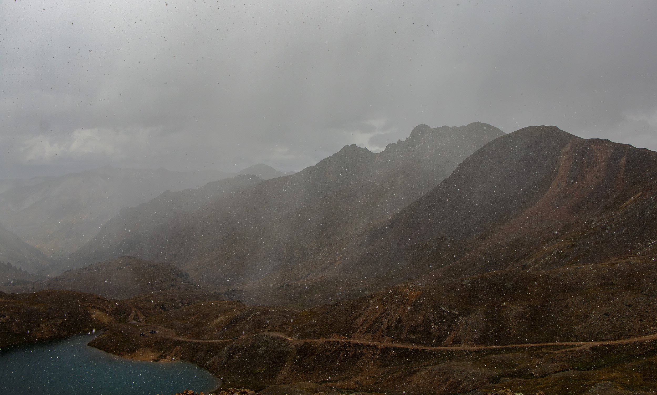
Blowing Snow & Poor Visibility:
This Colorado back country route itself is considered moderately challenging. It can be a little rocky and uneven in parts, and you absolutely need a 4wd high clearance vehicle in my opinion. This opinion is bolstered by the fact that on my own drive to reach the pass I encountered some heavy snow squalls and cloud mist (see photos & video clip below) that came out of nowhere and reduced visibility significantly and made travel a little sketchy at times. There were a few times I had to pull over trying to reach the old mining ghost town of Animas as I had trouble making out the edge of the narrow road and which direction I was heading. In fact, I did get lost and go the wrong direction and was lucky to meet a few guys on ATVs (one of the few people I encountered for over 3 hours) who told me to turn around as I had missed the turn to get to Animas Forks as I was heading towards Lake Como! I have no idea how I missed the turn other than I was distracted or poor visibility, but I would definitely recommend bringing an off road GPS navigation system with you travel on this Alpine road system .
Animas Forks Ghost Town:
When I finally got back on track and went the correct direction to reach Animas forks it was still blowing snow intermittently as I went over California Pass which sits at an elevation of nearly 13,000 feet. When I finally reached the old abandoned mining town about 1,800 feet lower it was still snowing but I felt relieved as I knew getting to the forest road over Cinnamon Pass was not far and well-marked. This was not the first time I have visited this really cool Ghost town, as I had visited a few years earlier on an ATV trip over Engineer pass.
If I recall it took me about 30-40 minutes after I left Animas Forks to reach the summit of Cinnamon pass which sits at an elevation of 12,620 feet. It was a slow crawl up as conditions had deteriorated again with limited visibility and horizontal blowing snow. See images and short video clip below. With these conditions there really wasn’t much of any views of the surrounding landscape and mountains going up or at the top of the pass. Oh, well, That’s life in the San Juan Mountains. From what I researched all the major passes in the Alpine loop ae generally closed come October because of heavy snowfall so Its not particularly unusual to see snow falling up this high in September.
Down The Hill To Lake City:
I did not linger long at the pass summit, maybe 10 minutes, and I did not see another vehicle roll up while I was there. On the way down the hill to the Lake City area I did pass one off-road touring company vehicle coming up the hill with a party who looked like they were enjoying the adventure. The road was a little tight in spots on this side of the pass but after descending for 30 minutes or so the snow started to gradually turn over to rain and mist and the visibility improved dramatically. So much so that I was finally able to enjoy some top level and remote mountain scenery as I made my way down to the Williams Creek Campground. I spent a rainy but comfortable night at the CG before hitting the road in the morning to meet up with my fly-fishing buddies along the Rio Grande river near Creede, Colorado- about an hour or so away.
Summary:
Would I go over Cinnamon pass again? Was it worth it? Absolutely! It was a little nerve wracking getting lost for a while because the visibility at times was atrocious on some very narrow and at times slippery roads, but I never felt like I was in any serious danger. Besides, I had a truck full of cold beer and supplies that would last for a week or more if I did get temporarily stranded. I would however be a little more diligent about checking the weather next time particularly as the cooler fall season rolls around in these mountains in early September. And again. you absolutely need a high clearance 4wd truck or ATV in my opinion to safely negotiate these high altitude back country roads.
More Info: Please feel free to contact me here if you have any questions or requests for content. Below you can see a number of images and a short video clip I captured on this adventure over Cinnamon pass.
Editing Services I Offer:
Photo Repair & Restoration: View info here about my old photo restoration services. This is a great way to digitize and preserve old memories.
Digital Video Editing: View info here about my affordable video editing services

At the top of Ophir Pass heading down towards Silverton and highway 550 to get to the Alpine Loop entrance.

Nice fall colors and scenery near the top of Ophir Pass.

Entrance off of highway 550 to the Alpine Loop.

The weather looked fairly decent when I began my off road adventure over Cinnamon Pass. But conditions can change rapidly in this true Alpine environment.
The weather began to change rapidly after I missed a turn and got lost!


Animas Forks ghost town ruins. This historic old mining town site is definitely worth a visit.

Heading up to the top of Cinnamon Pass.
I encountered blowing and horizontal snow when I reached the top of Cinnamon Pass.

Heading down to the Lake city area.

The weather and views began to improve as I descended down Cinnamon Pass road towards beautiful and historic Lake City, Colorado. Please contact me if you have any questions or feel free to leave a comment below.